
Publication Date: October 2026
Overview
- What: A historic, stone-built medieval Georgian defensive fortress that has survived intact to the present day [1].
- Where: Situated in a rocky gorge within the boundaries of Yıldırımtepe village, in the Çıldır district of Ardahan province [2].
- Why it matters: A defensive stronghold guarding the strategic passage between the Caucasus and Anatolia, bearing traces of antiquity [2].
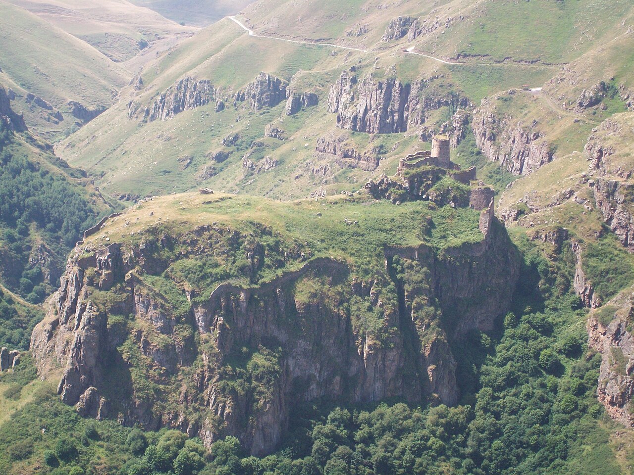
Defensive fortifications situated in the geography of Northeastern Anatolia hold profound significance. Over the centuries, these structures secured the region’s ancient transit corridors [3]. Among the surviving monuments of this regional defensive network is Şeytan Kalesi (Devil’s Castle). The fortress rises dramatically atop a rocky promontory located at the confluence of valleys [3].
The region bridges strategic routes between the Caucasus and Anatolia, placing it at a geographical crossroads of immense value [2]. Known in historical records as Palakatsio, this historical-geographical territory encompasses modern Çıldır and the surrounding basin of Lake Çıldır. It is within this historic Palakatsio district that this ancient stronghold stands. The fortress is regarded as one of the rare medieval heritage sites to have reached the present day in a substantially intact state [1].
Where is it?
Şeytan Kalesi is located along the northeastern border of Turkey, within the administrative boundaries of the Çıldır district in Ardahan province [3]. The historic structure is situated within the borders of Yıldırımtepe village, today considered a quarter of the town of Çıldır. The site is a registered cultural property designated for preservation [1].
The distance from the village settlement to the castle varies across sources. While some records cite this distance as 1.3 kilometers, others place it between 1.5 and 2 kilometers [3]. This slight discrepancy stems from understandable factors, such as differing starting points used during measurements or alternative walking routes leading to the castle [1].
In earlier eras, the settlement surrounding the structure was a vibrant commercial hub [1]. At the time, this settlement was known by the name Rabat [1]. Today, the term rabat may merely bring to mind the capital of Morocco. Historically and locally, however, the word refers to civilian settlements established directly at the foot of fortifications. In the past, marketplaces, outer suburbs, or commercial quarters where merchants lodged in proximity to a secure fortress were called rabats. Originally named Rabat, this commercial settlement underwent transformation over time, eventually attaining the identity of the present-day settlement [1].
In geographic coordinates, the fortress lies at latitude 41°09′15″ N and longitude 43°07′53″ E [1]. This historical complex was erected on an exceedingly precipitous hill, standing at an elevation of approximately 1,910 meters above sea level [1].
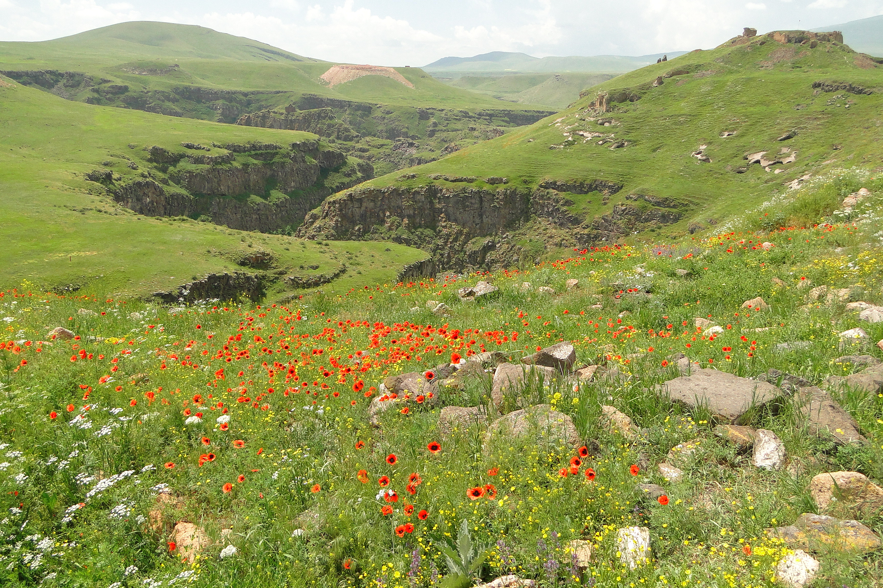
The fortress grounds are encircled by the Karaçay Gorge. It occupies a heavily fortified, highly defensible position atop a rocky promontory enveloped by this deep canyon [3]. Natural landforms significantly bolstered the security of the fortress: the northern, southern, and eastern flanks of this rugged peninsula consist of sheer slopes, with all three faces opening directly onto profound abysses [3].
Steep slopes stretch along the right bank of the stream flowing immediately beside the castle, transforming the area into a natural defensive position [1]. Approaching this rocky promontory—surrounded on three sides by sheer chasms—is arduous by land, and the site can be reached from only a single secure direction via an overland connection [1]. In the historical process, this strategic geographical position within the Palakatsio region of Çıldır and its environs afforded the structure a formidable advantage, providing the fortress with a natural defense that proved exceedingly difficult to overcome for centuries [1].
History & Origins
In Georgian historical records, the original name of the fortress appears as Kacistsikhe [1]. This term was translated into Turkish as Şeytan Kalesi (Devil’s Castle) [1]. In addition, alternative designations are found in various written documents; older regional records also refer to this defensive work directly as Çıldır Kalesi [1].
There is a direct reason why the fortress came to be known by such a stern and foreboding name: the structure was established on exceptionally challenging terrain, rendering its conquest virtually impossible in bygone eras [1]. A widespread popular legend sought to explain the perceived invincibility of the garrison within, and over time, this sense of invulnerability became associated with evil spirits and demonic powers [1].
Several viewpoints exist regarding the origins of the fortress, with some hypotheses asserting that the site was first established during the Urartian period [1]. However, the Urartian thesis remains unproven, as no written documentation confirming this claim has yet come to light [1].
Data provided by later sources paint a different picture, indicating that the fortress is an early medieval defensive work [1]. Nevertheless, archaeological surface surveys conducted in the area in 2017 yielded ceramic sherds dating back to the 5th and 4th centuries BC [3].
These ceramic fragments reflecting the Classical Antiquity period serve as a significant clue, suggesting that a degree of human activity and settlement existed on the site even in ancient times [3]. It is noted in published research that such ceramic finds directly linked to the Classical period had not previously been encountered in the archaeology of Northeastern Anatolia [3].
However, hasty conclusions should not be drawn from the recovery of a few ceramic fragments, as these sherds alone do not definitively prove the existence of a pre-medieval fortress [3]. Indeed, field investigations conducted by specialists revealed no architectural remains in or around the castle that could be dated to Antiquity [3]. The vast majority of the ceramic finds at the site belong to later eras, pointing to the medieval period between the 10th and 13th centuries AD [3].
A fortress is also mentioned in The Knight in the Panther’s Skin, the celebrated 12th-century epic penned by the renowned Georgian poet Shota Rustaveli [1]. The epic references the name Kajeti Castle (Kajta Tsikhe). While some have argued this refers to the famous Alamut Castle in Iran, strong scholarly arguments contest this view, and researchers emphasize the compelling likelihood that the structure described in the epic is indeed Şeytan Kalesi [1].
Throughout the Middle Ages, the fortress remained under the rule of the Kingdom of Georgia for many years before continuing its existence under the control of the Principality of Samtskhe-Saatabago [1]. Samtskhe-Saatabago was a local Georgian principality that held sway over southern Georgia and what are today Turkey’s border regions during the medieval era—an autonomous feudal realm led by rulers bearing the title of “Atabeg” [1].
An important written work chronicles regional developments from this era: a historical chronicle known in Georgian as Meskhuri Matiane [1]. The term chronicle (vakayiname) designates an official historical ledger recording the political and social events of a period in chronological order. This Meskhuri Matiane chronicle covers the regional events of the period between 1561 and 1587 in thorough detail [1].
According to the information related by this chronicle, Manuchar II, the ruler of Samtskhe-Saatabago, met with the Ottoman commander Lala Mustafa Pasha, leading to a diplomatic accord between the two leaders [1]. As a result of this official agreement, six fortified strongholds, including Şeytan Kalesi, were formally ceded to Ottoman administration [1].
The Ottoman Empire promptly registered these newly acquired territories. The castle was recorded in the detailed cadastral register (mufassal defter) of 1595 [1]. A mufassal defter is an official imperial survey in which the Ottoman administration registered, item by item and in meticulous detail, taxable assets, populations, villages, fortresses, and revenues in conquered or administered sanjaks. In this detailed survey of 1595, the name of the castle was recorded as Kacisiha, staying true to its Georgian pronunciation [1]. Intriguingly, in the very same register, the fortress name Tetra Tsikhe was translated into Turkish as Akçakale and Okros Tsikhe as Altunkale, while the original Georgian name of Şeytan Kalesi was preserved at that time [1].
The castle’s name was translated into Turkish only in the official correspondence of later eras, subsequently appearing in imperial documents under the form Şeytan Kala [1]. With the establishment of Ottoman sovereignty in the region, the strategic function of the structure endured, and the fortress continued to be utilized for military and logistical purposes from the 16th century onward [1].
Today, the monument stands in a considerably deteriorated state, facing severe conservation problems brought on by environmental weathering and anthropogenic damage [2]. Scientific investigations highlight a striking neglect, demonstrating clearly that no comprehensive restoration or conservation work has ever been carried out on the fortress to date [2]. A comprehensive archaeological excavation at the site is imperative to fully decipher its occupational layers and unravel its history [3].
Architectural Form
Şeytan Kalesi was constructed in close adaptation to the local topography. The complex exhibits an asymmetrical, organic layout that conforms entirely to the contours of the rocky promontory and the natural gradient of the terrain [1]. Measurements taken along the main perimeter walls record the overall dimensions of the fortress as 161 meters by 93 meters [1].
The architectural ensemble displays distinct characteristics, exhibiting the hallmark features of medieval Georgian defensive architecture through its stonework and formal arrangement [1]. In the past, three towers stood along the primary defensive perimeter; today, however, only one of these towers has managed to survive intact [1].
The principal bastion of the fortress rises along the western edge of the terrain, firmly planted upon the highest summit of the site [3]. The term bastion refers to multi-story stone towers that project at intervals along defensive walls to reinforce fortification lines [3].
Curtain walls branch out from this main bastion in two wings, descending in terraces along the boundary contours of the ridge toward the valley [3]. The concept of a curtain wall (beden duvarı) designates the thick, sturdy, and protective primary ramparts that connect bastions and towers to one another [3].
The spatial configuration created by the western main bastion and the curtain walls against the terrain is of architectural interest: this layout forms a triangular exterior forecourt [3]. Immediately outside the fortress gate positioned between two bastions, an ingenious defensive layout frequently employed in medieval military architecture was implemented [3].
In architectural terminology, this arrangement is known as a bent entrance (or bent-axis corridor). The bent corridor system renders the approach to the gate winding and angular, thereby preventing enemy forces from mounting a direct, rapid charge along a straight trajectory toward the main entrance portal [3]. As one approaches the fortress from the exterior, the slope steepens sharply, rendering the defensive perimeters virtually impregnable to outside assailants [3].
On the lower terrace of the fortress rise the remains of a single-nave Christian church dated to the 14th century [1]. The term “lower terrace” (or lower elevation) refers to a level situated lower relative to the main ground plane of the complex; that is, the church occupies a terrace below the central core of the fortress. The designation “single-nave structure” denotes houses of worship whose interior space is undivided by rows of columns, extending from end to end as an austere, single hall or corridor [1].
Very little remains of this small chapel, which appears to have been dedicated to Saint Stephen. Due to the ravages of time, only its four main stone walls remain standing [1]. Situated 23 meters northeast of this chapel is a circular cistern meticulously hewn directly into the bedrock [3].
A cistern is an element of vital importance to life within a fortress—a secure storage basin providing the garrison with a regular water supply during sieges and periods of drought [3]. Furthermore, a path descends from inside the fortress down to the valley floor; the stone steps carved into the bedrock along this route were built to facilitate secure access to the stream and remain preserved to this day [1].
Another set of architectural remains, rectangular in plan, stands abutting the southwestern ramparts of the castle [3]. This structure was erected using masonry construction techniques [3]. The term masonry (kâgir) structure refers to buildings whose load-bearing systems dispense with timber, constructed directly from rigid, fire-resistant materials such as stone, brick, and mortar. According to research, this rectangular space is thought to have served historically as a storeroom or pantry [3].
Additional structural traces are discernible to the north and northwest of the circular cistern, where the outlines of stone structures surviving only at foundation level can be observed [3]. In-depth archaeological excavations at the site are required to definitively establish the original functions of these foundation remains [3].
The site features no classical marble columns or inscriptions [3]. Nor are there prominent ornamental or decorative motifs on the stone surfaces of the fortress. A strictly functional and austere defensive rationale governs every line of the complex [1].
Visiting Notes
Transportation options are available for those wishing to visit Şeytan Kalesi. A paved vehicular road extends as far as the observation overlook located near the structure [1]. From this viewpoint, where the motor road terminates, visitors must proceed on foot. Access to the fortress is provided via a walking trail that traverses the rocky hillside [1].
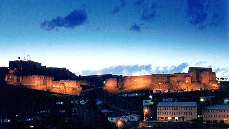
Careful footing is essential along this path descending toward the rocky peninsula, and one must remain mindful of the stony ground and steep slopes throughout the walk [3]. Today, the fortress is among the notable historic monuments illuminated at night [1].
Thanks to this nocturnal illumination, the fortress silhouette rising above the valley presents an impressive spectacle, allowing the historic monument to be viewed comfortably from the opposite observation hill during evening hours as well [1]. Specific visiting hours, prospective admission fees, and current transit options are not recorded in written sources; travelers are therefore advised to confirm these details with official local authorities prior to departing [1].
To date, no comprehensive restoration work has been carried out at the fortress. As a consequence, substantial material losses and serious degradation are evident along the walls and internal structures [2]. Caution should be exercised when touring the fortress, which is surrounded on three sides by the deep chasms of the Karaçay Gorge, and visitors must pay meticulous attention to personal safety precautions [3]. Preserving this rare cultural heritage site—worn down by natural weathering and human-induced damage—is of utmost importance; visitors should take care never to damage the building stones and to keep the surrounding environment clean [2].
References
- [1] Şeytan Kalesi - Vikipedi (ADRES: https://tr.wikipedia.org/wiki/%C5%9Eeytan_Kalesi)
- [2] Ardahan-Çıldır Şeytan Kalesi Korunma Sorunları ve Çözüm Önerileri — Yusuf ÇETİN, Ebru Karakoç (2024, DergiPark (Istanbul University)) (ADRES: https://dergipark.org.tr/tr/pub/palmet/issue/87373/1516976)
- [3] ŞEYTAN KALESİ’NİN ANTİK DÖNEM BULUNTULARI — Sami Patacı (2020, DergiPark (Istanbul University)) (ADRES: https://dergipark.org.tr/tr/pub/belgu/issue/55301/678090)
Konum
Harita: © OpenStreetMap katkıcıları. Haritada büyüt · Google Haritalar · Apple Haritalar
İşaret yaklaşık konumu gösterir; kesin konum için yerel kaynaklara bakın.
This article is compiled from scholarly monographs and official architectural inventories. Please verify site access conditions, visiting hours, and ongoing conservation status via official heritage authorities prior to visiting.