


Summary
- What is it? A ten-pointed star-plan cylindrical brick tower mausoleum constructed during the lifetime of Ziyarid ruler Şemsü’l-Meâlî Kābûs b. Veşmgîr in Hicrī 397 (CE 1006–1007) and Yezdicerdī 375 [1], [2].
- Where is it? Located on an artificial hill within the city center of Gonbad-e Kavus, 3 kilometers north of the historical Jorjan ruins in the Golestan Province of northeastern Iran, named directly after this monument [1], [3].
- Why is it significant? The tallest intact brick tower in early Islamic architecture (53 meters from base to dome, exceeding 60 meters with the artificial hill); inscribed on UNESCO’s World Heritage List in 2012 [1], [4].
- Architectural Typology: Cylindrical body adorned with ten sharp triangular prism protrusions (“star teeth”), conical brick dome, double-wall covering system, and one of the earliest examples of muqarnas corbeling at its entrance portal [1], [5].
Historical Context and Construction Process
The Tabaristan and Jorjan region south of the Caspian Sea in northern Iran fell under the rule of local Deylem and Gilan-origin dynasties following the decline of the Abbasid Caliphate [1], [2]. Among these, the Ziyarids (931–1090) established a unique court organization and artistic environment synthesizing Islamic civilization with ancient Sasanian-Iranic cultural heritage [2]. Ziyarid ruler Şemsü’l-Meâlî Ebü’l-Hasan Kābûs b. Veşmgîr (reign: 978–981 and 998–1012) was not only a powerful emir but also a polymath—poet, calligrapher, and patron of astronomy [2]. The renowned Islamic scholar Abū Rayhān al-Bīrūnī dedicated his seminal work el-Âsârü’l-bâkıye on calendars and chronology to Kābûs; young physician Ibn Sina also journeyed to the Jorjan court to attend his scholarly assemblies [2], [4].
The two bands of inscriptions on the tower’s façade confirm that construction began while Kābûs was still alive, completed in Hicrī 397 (CE 1006–1007) and Yezdicerdī 375 [1], [5]. The use of the term “el-kasrü’l-âlî” (“the lofty palace”) rather than classical funerary terminology (kabir, türbe, ravza) indicates that the structure was conceived not merely as an eternal resting place but as a cosmic and dynastic symbol of Ziyarid authority [1], [5].
In early 11th-century Jorjan, the region represented a multi-layered cultural crossroads where Zoroastrian traditions were still transitioning to Islam [1], [6]. Art historians Oleg Grabar and Melanie Michailidis emphasize that the monument’s soaring silhouette, its elevated base preventing direct contact with the earth, and the dual calendar system in the inscriptions reflect a synthesis of ancient Sasanian towers and Zoroastrian funerary practices with Islamic mausoleum architecture [1], [6]. Whether Kābûs b. Veşmgîr was interred here remains a historical enigma; according to the well-known account by historian Ibn Isfandiyār, his body was placed in a transparent sarcophagus made of glass or crystal, suspended from the ceiling via iron chains and illuminated by morning sunlight through an eastern window [1], [3]. No burial chamber, sarcophagus, or skeletal remains were found during Russian archaeologists’ excavations at the tower’s base in the late 19th century, confirming the absence of a crypt beneath the structure [1], [5].
Architectural Plan and Spatial Composition
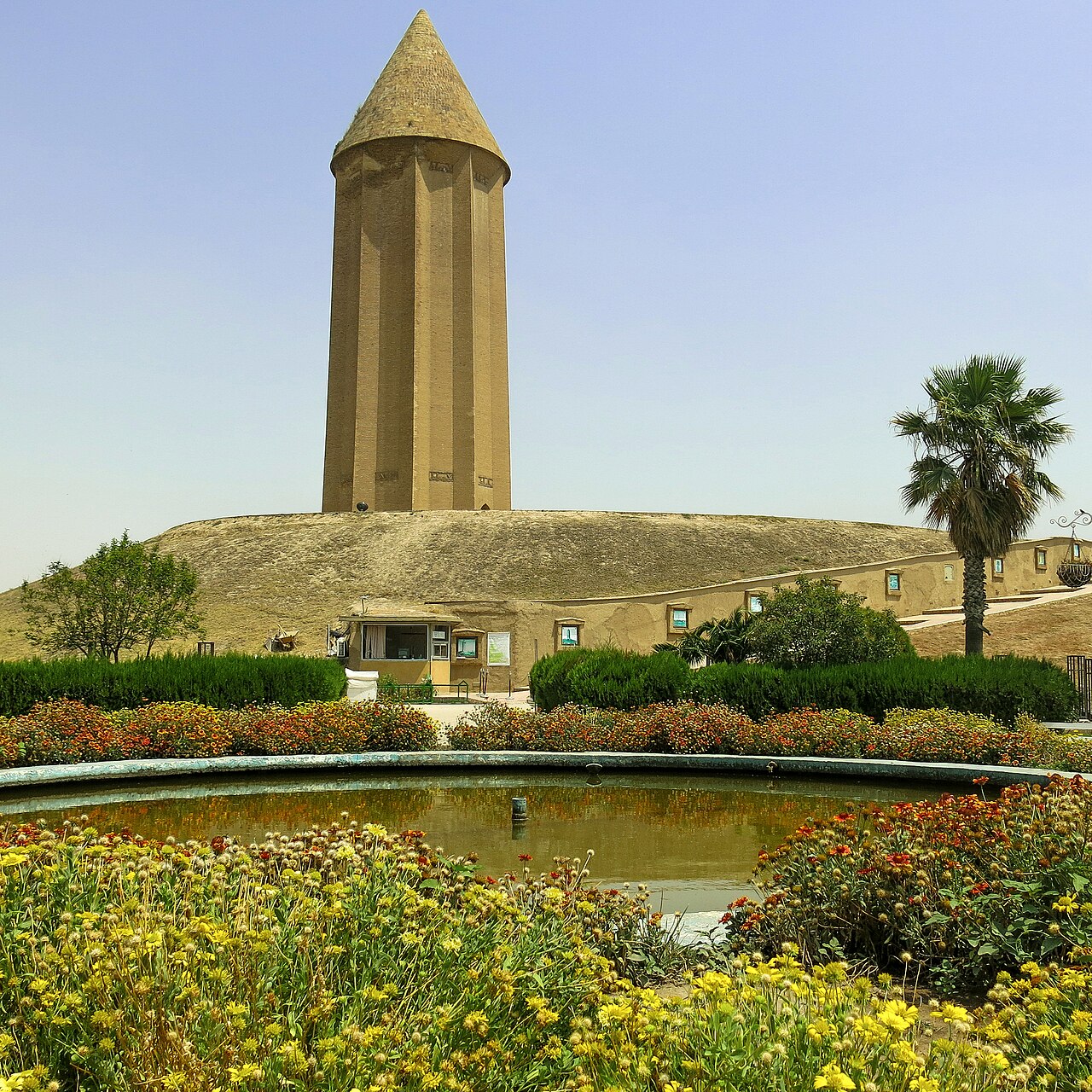
Kümbed-i Kābûs was constructed on an artificial earthen mound (höyük) approximately 15 meters above sea level [1], [4]. This engineered elevation allows the tower to function as a single visual landmark visible for kilometers across the endless Turkmen Desert plains [1].
The structure’s base is circular with an external diameter of 17 meters at ground level [1], [5]. Ten triangular prismatic wings (“star teeth”) extend vertically from the base to the apex of the conical dome, creating a ten-pointed star-plan profile on the façade [1], [3]. These triangular protrusions, intersecting at 90-degree angles, measure 1.46 meters in width and approximately 1 meter in depth at the base [1]. In addition to providing extraordinary wind resistance and aerodynamic flexibility, these wings generate dramatic shifts in light-shadow patterns across the façade throughout the day [1], [6].
The architectural dimensions of Kümbed-i Kābûs represent a remarkable feat of early medieval brick engineering [1], [4]:
- Body Height: 37 meters from the artificial mound to the eaves of the conical dome [1].
- Conical Dome Height: 18 meters from the eaves to the apex [1].
- Total Structural Height: Approximately 53 meters from the artificial mound to the dome’s summit; exceeding 60 meters when including the massive circular substructure [1], [5].
- Wall Thickness: The solid brick walls measure 4.80 meters at the base, tapering gradually to 3.65 meters at the eaves [1].
- Interior Diameter: The interior space is a fully cylindrical void with a diameter of 9.67 meters at ground level, contrasting with the ten-pointed star-plan exterior [1].
The roof system employs a double-wall vaulting mechanism [1], [5]. From within, the cylindrical chamber is capped by a semi-spherical brick inner dome; above this, an unbroken single-piece conical brick dome rises 18 meters vertically from the eaves to the apex [1]. A small window slit near the eastern façade of the dome allows indirect light to penetrate into the tower’s interior [1], [3].
Stone Decoration, Ornamentation, and Inscriptions
Unlike later monumental tombs adorned with intricate tilework or carved stone reliefs, Kümbed-i Kābûs is a minimalist masterpiece emphasizing the raw plasticity of its brick structure [1], [6]. The material used—high-quality solid bricks fired at high temperatures from the region’s hard clay soil—exhibits a pale straw-yellow hue [1], [4]. These bricks were bonded with a specialized hydraulic mortar (saruc) composed of lime, ash, and plaster; over centuries, this mortar has petrified, merging seamlessly with the brickwork to confer monolithic structural integrity [1].
The sole decorative element consists of two bands of monumental kufic inscriptions encircling the tower’s body [1], [5]. The first band is positioned 8 meters above the entrance portal; the second band lies at the level of the eaves of the conical dome [1]. Each band comprises ten individual frames embedded within the gaps between the outward-facing triangular protrusions [1], [5].
The inscriptions, carved with a refined and austere celî kufic script directly into the fired brick surfaces, contain the following seci’li (rhymed prose) Arabic text [1], [5]: “Bismillâhirrahmânirrahîm. Hâzâ el-kasrü’l-âlî li’l-emîr Şemsi’l-Me’âlî el-emîr İbni’l-emîr Kābûs bin Veşmgîr. Emera bi-binâihî fî hayâtihî sene seb’a ve tis’în ve selâsemie hicriyye kameriyye ve sene hamse ve seb’în ve selâsemie şemsiyye.” (“In the name of Allah, the Most Gracious, the Most Merciful. This lofty palace belongs to Emir Şemsü’l-Meâlî, Emir son of Emir Kābûs b. Veşmgîr. He ordered its construction during his lifetime in the year 397 H (CE 1006–1007) and 375 Yezdicerdī.”) [1], [5].
The repetition of this text at two distinct heights on the tower reflects a deliberate design choice to ensure legibility both from ground level and by distant caravans traversing the plains [1], [6]. Additionally, the coexistence of Hicrī (Islamic) and Yezdicerdī (Sasanian-derived solar) calendar systems in the inscription underscores the dual cultural legitimacy sought by Ziyarid rulers during this period [1], [2].
The single eastern entrance portal is framed by a pointed brick arch [1]. The stepped recesses within this arch’s muqarnas corbeling are recognized by art historian Sheila Blair as the earliest documented example of muqarnas ornamentation in Iranian architecture [1], [5]. This embryonic stage of muqarnas represents a foundational archaeological evidence for the development of stalactite vaults in Islamic architecture [1], [5].
Waqf System and Social Function
Kümbed-i Kābûs functions as a multifunctional monumental structure overseeing the security of medieval Islamic trade routes and frontier regions [1], [3]. The historical city of Jorjan was one of the busiest commercial and artisan centers along the northern Silk Road connecting Khurasan to the Caspian coast via Rey and Baghdad [2], [4].
The inscription’s use of “el-kasrü’l-âlî” (“the lofty palace”) reveals the structure’s multifaceted roles beyond its funerary function [1], [5]:
- Beacon Tower (Menâre / Mil): Serving as a colossal caravan beacon, visible from distances exceeding 30 kilometers during daylight and illuminated by fires at the dome window at night for navigation [1], [3].
- Dynastic Symbol of Power: A military prestige monument asserting Ziyarid authority over nomadic Turkmen tribes and settled Deylem-Iranic communities [1], [2].
- Astronomical Observatory: Given Kābûs b. Veşmgîr’s close association with the astronomer al-Bīrūnī, scholars suggest the tower’s perfect cylindrical vertical shaft and summit window may have been used for celestial observations [2], [4].
To ensure maintenance of the structure and its surrounding settlement, Kābûs willed the revenues from irrigated orchards and farmland in the Jorjan plain as a waqf endowment [2], [3]. Historical records indicate that waystations (ribat and zaviye) were established around the tower for travelers; this waqf system remained active until the Mongol invasion [2], [3].
Restoration History and Conservation Status
Kümbed-i Kābûs has withstood over a millennium of earthquakes, storms, and invasions with extraordinary resilience [1], [4]. This durability stems from the bricks’ exceptional firing quality, 4.8-meter wall thickness, and the artificial mound’s seismic damping properties [1], [6].
The first comprehensive documentation and restoration efforts in modern times were conducted in the 1930s under French architect and archaeologist André Godard [1], [3]. During these repairs, the eroded slopes of the artificial mound were reinforced with stone retaining walls, and the summit was transformed into a city park [1].
In the 1970s, the Iranian Department of Antiquities restored fractured bricks in the conical dome using original materials and filled mortar joints on the façade with hydraulic lime mortar [1], [4]. A multidisciplinary restoration project initiated in 2010 analyzed the structure’s moisture regime, wind loads, and mortar composition via laser scanning; in 2012, the monument was inscribed on UNESCO’s World Heritage List under number 1398 [1], [4].
Today, the monument is protected by the Golestan Provincial Directorate of Cultural Heritage, Tourism, and Handicrafts [4]. Annual cultural symposiums are held at the site to commemorate the city’s founding anniversary and UNESCO inscription date [4].
Frequently Asked Questions
Is Kümbed-i Kābûs a tomb or a watchtower?
Architecturally, it belongs to the northern Iranian mausoleum tradition; however, its inscriptions refer to it as “el-kasrü’l-âlî” (“the lofty palace”) [1], [5]. Functionally, it serves multiple roles: as a caravan beacon, dynastic symbol of Ziyarid authority, and astronomical observatory [1], [3].
Where is Kābûs b. Veşmgîr’s remains?
According to the popular account by historian Ibn Isfandiyār, the ruler’s body was placed in a glass sarcophagus suspended from the ceiling of the tower’s inner dome via iron chains and illuminated by sunlight through an eastern window [1], [3]. However, archaeological excavations in the 19th and 20th centuries found no burial chamber, sarcophagus, or skeletal remains within the tower; its interior is a completely empty vertical space from base to summit [1], [5].
What do the two distinct dates on the inscription signify?
The construction date is inscribed using both Hicrī Kameri 397 and Yezdicerdī 375 calendars, reflecting the coexistence of Islamic and pre-Islamic solar calendar systems in the region during the early 11th century [1], [5]. This dual dating represents a rare epigraphic document illustrating cultural continuity between Sasanian-Iranic traditions and Islamic chronology [1], [2].
Why was it constructed with a ten-pointed star plan?
The addition of ten triangular prismatic protrusions to the cylindrical body disrupts the uniformity of a simple tower, creating dynamic light-shadow rhythms on the façade [1], [6]. Simultaneously, these wings provide high aerodynamic resistance and static stability against open-steppe storms [1].
References
- [1] Sheila S. Blair, The Monumental Inscriptions from Early Islamic Iran and Transoxiana, Leiden: E.J. Brill, 1992, pp. 61–65.
- [2] Erdoğan Merçil, “Kâbûs b. Veşmgîr”, TDV İslâm Ansiklopedisi, vol. 24, İstanbul 2001, pp. 35–37.
- [3] Sema Doğan, “Kümbet”, TDV İslâm Ansiklopedisi, vol. 26, Ankara 2002, pp. 560–563.
- [4] UNESCO World Heritage Centre, “Gonbad-e Qābus”, World Heritage List No. 1398, Paris 2012.
- [5] Arthur Upham Pope, A Survey of Persian Art from Prehistoric Times to the Present, Oxford University Press, 1939, vol. II, pp. 970–974.
- [6] Oleg Grabar, “The Earliest Islamic Commemorative Structures, Notes and Documents”, Ars Orientalis, vol. 6, 1966, pp. 7–46.
Konum
Harita: © OpenStreetMap katkıcıları. Haritada büyüt · Google Haritalar · Apple Haritalar
İşaret yaklaşık konumu gösterir; kesin konum için yerel kaynaklara bakın.
This article is compiled from scholarly monographs and official architectural inventories. Please verify site access conditions, visiting hours, and ongoing conservation status via official heritage authorities prior to visiting.